Colors and Types
Runway markings are white. Yellow is used to mark taxiways, closed areas, hazardous areas, and holding positions. A runway may be marked as a visual runway, a nonprecision instrument runway, or a precision instrument runway.
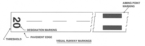
Visual Runway Markings
A visual runway is intended for use by aircraft being operated under visual flight rules (VFR). The markings on a visual runway include:
- Designation
- Centerline
- Threshold
- Aiming Point
On a visual runway, threshold markings are only required if the runway is intended for use by international commercial transports. The aiming point marking is only required on runways 4,000 feet or longer, which are used by jet aircraft.
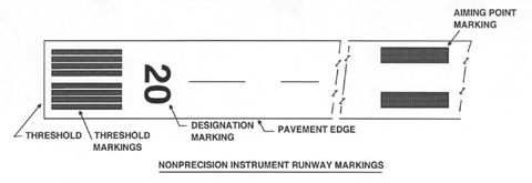
Nonprecision Instrument Runway Markings
A nonprecision instrument runway is intended for use by aircraft operated under VFR or instrument flight rules (IFR) and is served by a nonprecision instrument approach. A nonprecision instrument approach allows the pilot to descend in instrument flight conditions, but provides lateral guidance only. The pilot on a nonprecision approach simply descends to a minimum altitude, flies a prescribed course, and attempts to pick up the airport visually and land.
The markings of a nonprecision instrument runway include:
- Designation
- Centerline
- Threshold
- Aiming Point
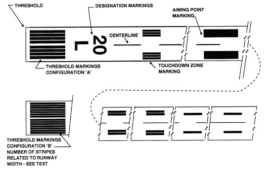
Precision Instrument Runway Markings
A precision instrument runway is intended for use by aircraft operating under VFR or IFR and is served by a precision instrument approach. A precision instrument approach provides instrument pilots lateral and vertical guidance which places them just off the end of the runway and at the correct altitude. The approach procedure is designed to place these pilots in a position to pick up the approach lights. The approach lights guide them to the runway end, and the precision runway markings guide them throughout the landing and landing roll.
Precision instrument runway markings include:
- Designation
- Centerline
- Threshold
- Aiming Point
- Side Stripe
- Touchdown Zone
Runway Designation Markings
Runways are designated with a number that is determined by the runway's magnetic orientation rounded to the nearest ten. For example, if a runway was oriented to a magnetic direction of 212 degrees, the runway would be designated as runway 21. A pilot landing on runway 21 will be flying pretty close to 210 degrees on final approach and landing.
By designating runways in this way, a pilot is automatically aware of the direction of takeoff or landing when using a particular runway. For example, a pilot using runway 36 automatically knows that this runway faces north. When the pilot uses this runway for takeoff or landing, the airplane will be heading pretty close to 360 degrees.
You can takeoff and land on a runway in either direction. So, at the end of the runway opposite runway 36, we should expect to see a big 18. Runway 18 and runway 36 refer to the same piece of concrete or asphalt. But, if you takeoff or land going south, then you're using runway 18.
Many airports have multiple parallel runways. This could make the runway designation system we have here pretty confusing, since at an airport like this, there are multiple runways facing the same direction. If, for example, an airport had two north-south runways, then "L" and "R" would be added to the runway designations. The letters are short for left and right. In this example, the runway on the east side of the airport would be 36R if landing north and 18L if landing south. The west runway would be referred to as 36L or 18R.
If there are three runways facing the same direction, "C" may be used, which means center. If the airport authority wants more than three parallel runways, they will actually construct the runways so they face a slightly different direction to avoid coming up with some kind of confusion. For example, they may have runways 36L, 36C, 36R, and runway 1.
Runway Centerline Markings
Runway centerline markings provide pilots alignment guidance during takeoff and landing. The markings consist of white dashed lines down the center of the runway.
Runway Threshold Markings
Runway threshold markings can be eight longitudinal stripes of uniform dimensions, four on each side of the runway centerline, located prior to the runway designation markings. The number of stripes may be altered, however, to indicate runway width at some airports. If this type of threshold marking system is used, then four stripes indicate a runway at least 60 feet wide. Six strips are used for a 75 foot wide runway. Eight stripes are used for 100 feet. Twelve stripes are used for 150 feet. Finally, 16 stripes would be used for a runway that was 200 feet or greater in width.
Relocated Thresholds
It is sometimes necessary, due to construction or runway maintenance, for example, to close only a portion of a runway. When a portion of a runway is closed, the runway threshold will be relocated, as necessary. It is referred to, logically, as a relocated threshold. Methods for identifying the relocated threshold vary. It is common for the relocated threshold to be marked as a ten foot wide white bar across the width of the runway. When the threshold is relocated, the closed portion of the runway is not available for use by aircraft for takeoff, landing, or taxi. You should find out about the closure of a runway or portion of a runway before the flight by checking NOTAMs.
Displaced Thresholds
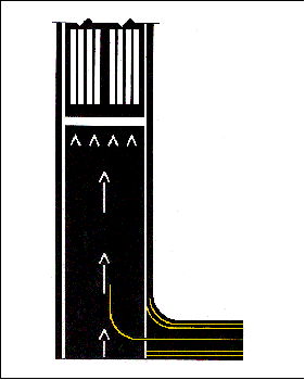
We pilots love to pull of those landings that leave our passengers unable to determine the moment of touchdown, leaving them to experience surprise that we've already landed or confusion about how the airplane could be flying so slowly. We can then climb out of the airplane with pride and act like some kind of magician. Sometimes, unfortunately, we are not quite able to execute this type of landing and opt for the less desirable aircraft carrier style landing. This, by the way, is an excellent reason to bring along a second pilot (someone to blame it on). As a result, runways must be constructed to take a pounding, which makes their construction very expensive. Since airplanes require more distance to takeoff than they do to land, some airports built a cheaper extension to a runway. This extension is cheaper and works fine when used for taxi, takeoff, and landing rollout from the opposite direction runway. It cannot withstand the punishment that could be provided by landings, however. This area, which is unusable for landing, is marked by a displaced threshold.
A displaced threshold is marked with a ten foot wide white bar across the width of the runway, called a runway threshold bar. White arrows heads are placed just prior to the displaced threshold bar, and white arrows are placed along the centerline in the area between the beginning of the runway and the displaced threshold. These markings make the area unusable for landings clearly distinguishable to the pilot.
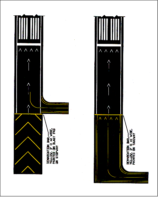
The Demarcation Bar
Some runways have blast pads or stopways. A blast pad not usable for taxi, takeoff, landing, or landing rollout. It is merely an area off the end of the runway, which is paved to prevent erosion by jet and prop blast. A stopway is a paved area off the end of the runway, which is to be used in the event of an emergency overrun situation, in which a landing aircraft was unable to stop on the runway. A stopway is not intended for any other use. It is not usable for taxi, takeoff, landing, or landing rollout.
A demarcation bar delineates a runway with a displaced threshold from a blast pad, stopway, or taxiway that precedes the runway. It is a three foot wide, yellow line across the width of the pavement or unusable area just prior to the beginning of the runway.
Areas that are unusable for taxi, takeoff, landing, and landing rollout are marked with large, yellow chevrons.
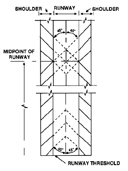
Runway Aiming Point Markings
The aiming point markings consist of a broad white stripe located on each side of the runway centerline, approximately 1,000 feet from the landing threshold, which serve as a visual aiming point for landing aircraft.
Runway Side Stripe Markings
These markings delineate the edge of the runway, providing pilots a visual contrast between the usable runway surface and nearby terrain or shoulder, which are unusable. Yellow runway shoulder stripes may be used to supplement runway side strips, in order to aid pilots in the identification of pavement areas near the runway, which are unusable.
Touchdown Zone Markings
Touchdown zone markings consist of one, two, and three rectangular bars symmetrically arranged in pairs about the runway centerline at 500 feet increments. These markings identify the runways touchdown zone. If a runway has touchdown zone markings on both ends of the runway, some of the touchdown zone markings near the center of the runway may be eliminated, if the length of the runway results in the two sets of markings coming too near each other.
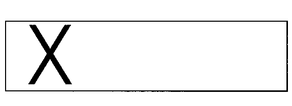
Closed Runway Markings
A closed runway is marked with yellow crosses at each end of the runway or raised yellow lighted crosses at each end of the runway. If permanently closed, yellow crosses are also placed at 1,000 foot intervals along the entire runway. When a runway has been closed a significant amount of time, these crosses may be faded, worn, or damaged by the disintegration of the pavement on which they were placed.
If a runway is closed temporarily, a runway closure may have no visual indication. Pilots should check NOTAMs and the ATIS for local runway and taxiway closure information.