The radar summary chart is a graphic, issued hourly, which is based on radar weather reports. It shows radar precipitation data, severe thunderstorm watches, and tornado watches.
The chart displays precipitation only. It does not show clouds. So, a clear area on the radar summary chart is not necessarily clear of weather, there was just no precipitation detected by radar in that area.
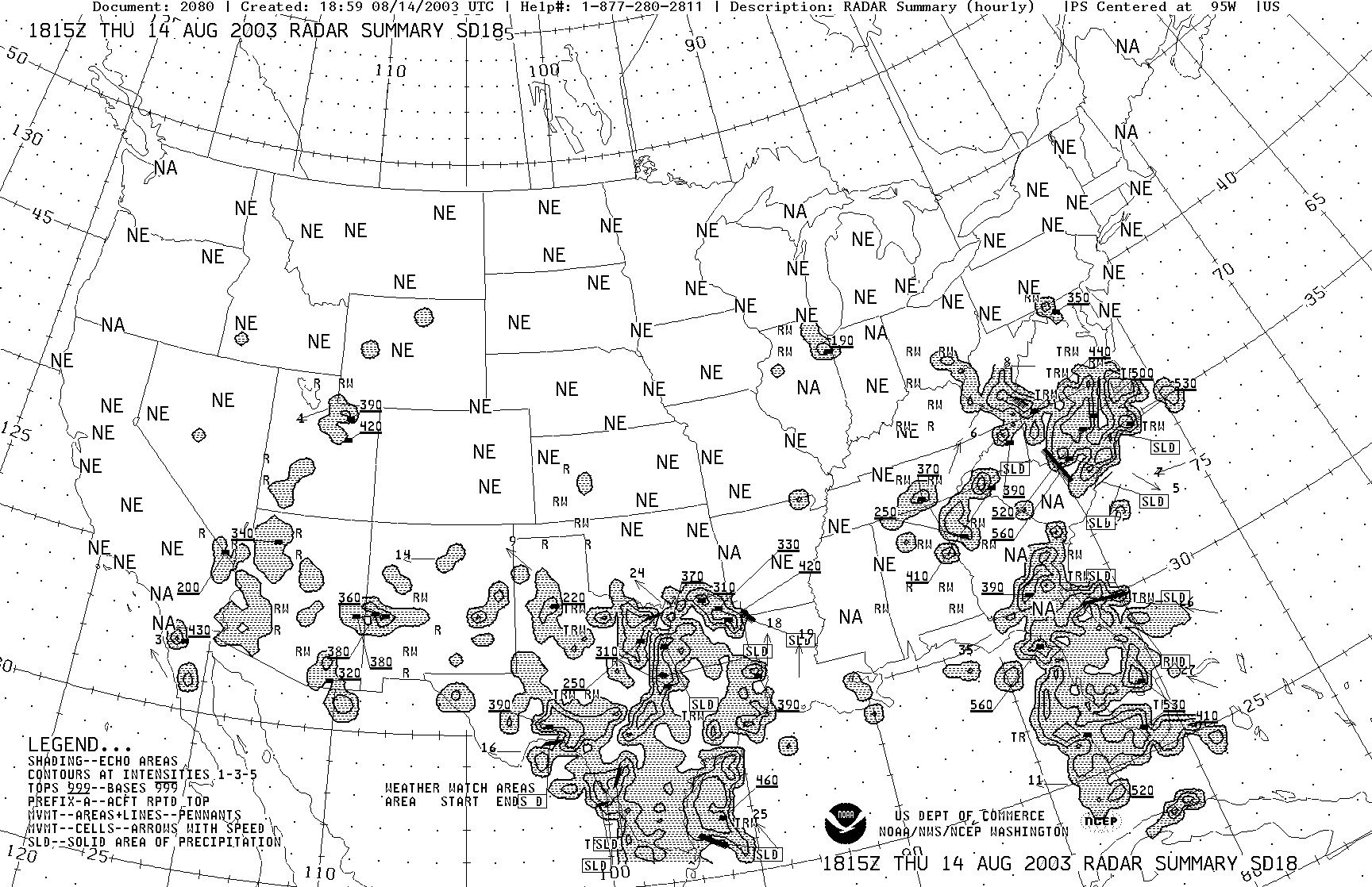
Precipitation Intensity
Precipitation intensity is shown in three contours.
The first contour indicates light to moderate precipitation.
A second contour indicates the presence of heavy precipitation. This area may also contain small hail granules.
The third contour depicts areas of extreme precipitation. These areas contain very heavy rain, and hail, which is pea size, marble size, or larger. Intensity information is shown for liquid precipitation only. It is not depicted for solid precipitation, such as snow.
Line of Precipitation
A line of thunderstorms is indicated on the chart by a solid line drawn through the radar returns. If there is 8/10’s or greater coverage along a line, the line is considered solid, and an “SLD” label will be placed on the chart at both ends of the line.
Precipitation Type
Letters on the radar summary chart indicate the type of precipitation. These letters have the same meaning on the radar summary chart as they do in the textual radar weather report. R for rain, RW for rain shower, S for snow, SW for snow shower, and T for thunderstorm.
Freezing precipitation is not plotted on the radar summary chart.
Average Movement
The average motion of radar returns is shown by arrows on the chart. A number next to the arrow represents speed in knots. LM means little movement.
Maximum Tops
Also depicted on the radar summary chart are the maximum tops of the precipitation detected by radar, in hundreds of feet above sea level. A small black dot on the chart depicts the location of the maximum tops.
Radar Site Status
If a radar site has the letters NE printed over it, it means no echoes were observed at this radar site. NA means the site is not available, and OM means it is out for maintenance. NA and OM both indicate data from that radar site was not included in this radar summary chart.
Severe Weather Watch Areas
If severe weather watches exist during the chart’s valid period, they will be depicted by dashed lines on the chart. The type of watch and its designation number will be displayed next to the northeast corner of each watch box. WT means tornado watch, whereas WS stands for severe thunderstorm watch.