Airport Tower Communications
An alphabetical listing of towered airports is provided on the chart tab. The tab contains the airport's name, tower operating hours, and the tower, ground, and ATIS frequencies. A star next to the tower frequency indicates the availability of airport advisory service by the flight service station, which is located on the airport, whenever the tower is closed.
On the right side of the tab, ASR or PAR approach availability for these airports is shown. These are approaches in which an air traffic controller uses radar to provide radio instructions to aid a pilot's let down in instrument conditions.
Approach Control Communications
Class B, C, D, TRSAs, and other selected radar facilities are shown alphabetically in the chart tab, along with their frequencies and hours of service.
Special Use Airspace
The chart tab also contains a numerical or alphabetical listing of special use airspace. Military operations areas are listed in magenta print, while other special use airspace is listed in blue ink. Names, altitudes, hours of operation, and the controlling agency of the special use airspace are listed.
Map Legend
The map legend is shown on the chart tab.
Chart Effective and Expiration Dates
The chart effective date is shown on the chart tab. The chart's expiration date is shown just below the effective date. A chart should not be used for navigation after its expiration date.
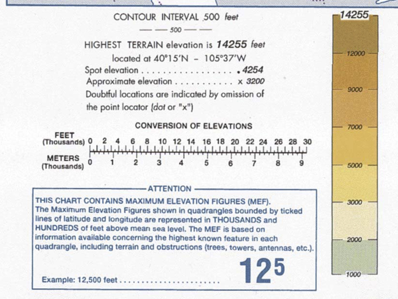
Chart Elevation and Contour Information
The chart tab shows the contour interval used for the chart, along with any intermediate or auxiliary contours used. A series of color tinted boxes illustrates the different color tinting for terrain elevations depicted on the chart, along with the highest terrain elevation on the entire chart. The highest terrain elevation and its latitude/longitude location is also written here.