The Airport/Facilities Directory is a directory of all public airports, seaplane bases, and heliports, issued for seven geographical areas: northwest, southwest, north central, south central, east central, northeast, and southeast. It is updated every eight weeks and is available at pilot supply stores or the following address on the FAA's website:
http://aeronav.faa.gov/index.asp?xml=aeronav/applications/d_afd
The beginning of the A/FD contains general information and abbreviations, as well as a legend. Next follows the airport and facilities directory. Near the back of the A/FD is included several supplements: notices, land and hold short information, FAA phone numbers, National Weather Service phone numbers, FSS communications frequencies, routes and waypoints for the area, parachute jumping areas, aeronautical chart bulletins, airport diagrams, NWS upper air observing stations, and EFAS outlets. One important supplement included in the back of the A/FD is a list of VOR receiver checkpoints, which allow pilots to check VOR receiving equipment on the aircraft.
Below is an example listing in the A/FD for the airport in Kirksville, MO. The key to decoding the A/FD entries is to refer to the legend anytime you are unsure of an entry or symbol's meaning.
We see that the name of the airport is Kirksville Regional, ICAO identifier IRK. The airport is located 6 miles southeast of the town of Kirksville.
To convert Zulu (UTC) to local time, subtract 6 hours during standard time or 5 hours during daylight savings. Next we are given the latitude and longitude location of the airport next. On the next line, the airport elevation is shown as 966 feet MSL. The "B" indicates an airport beacon operates at this airport, while "S4" indicates the level of service which can be provided. S4 means major airframe and major powerplant repair services are available here. 100LL and JET-A fuels are available at this airport.
The classification refers to the airport certification for use by commercial operators. A Class III airport may be used by a scheduled air carrier operating a 10 to 30 seat aircraft, which isn't of much concern to us. The ARFF index is also listed for use by commercial operators and is not really useful for our purposes. It details the level of firefighting services available upon request to commercial operators. Continuing on, the "NOTAM FILE" portion is also not relevant for us, since we obtain pertinent notams by obtaining a preflight weather briefing.
Each runway is of the airport is detailed in the A/FD. Here we see that runway 18-36 is a hard surface runway 6,005 feet long and 100 feet wide, made of concrete. "S-30, D-48, 2D-85" is also likely not pertinent to our operation, since it details runway strength. Runway 18-36 is capable of handling aircraft with a single wheel type landing gear of up to 30,000 lbs, dual wheel type landing gear aircraft up to 48,000 lbs, and aircraft with two dual wheels in tandem of up to 85,000 lbs.
Runway 18-36 is lit with medium intensity runway lights (MIRL). Runway 18 has runway end identifier lights and a 4-box VASI on the left side of the runway. The VASI projects a glide path angle of 3 degrees, which places the aircraft at a runway threshold crossing height of 33 feet. There is a tree off the approach end of this runway. Runway 36 is served by medium intensity approach lighting system with runway alignment indicators and a 4 box VASI on the left side of the runway, projecting a 3 degree glide angle. On glide path runway threshold crossing height is 54 feet.
There is also a 1,393 by 100 foot turf runway, designated 9 and 27. Both of these runways have tree off the approach ends.
Of note about all four of these runways are a few things that are NOT said. No runway slope information is mentioned. This means the runways are flat (having a slope of less than 0.3%). Also, since "Rgt tfc.", was not stated for any of these runways, then we are to assume a standard left hand traffic pattern is to be used for all of them.
The airport is attended between 1300 and 0100 Zulu. The ++ symbol next to the times means that during periods of daylight savings time the hours will be one hour earlier than shown. Self-service 100LL fuel is available with a credit card 24 hours a day. Runway 9-27 is marked with yellow cones. The medium intensity runway lights and VASIs for runways 18 and 36, the runway 18 REILs, and the runway 36 MALSRs are pilot controlled lighting systems. They are activated over the CTAF frequency.
ASOS for Kirksville is broadcast continuously on 121.125 MHz and is also available by calling 660-665-9153. A nearby HIWAS outlet is available via IRK Vortac, on frequency 114.6 MHz.
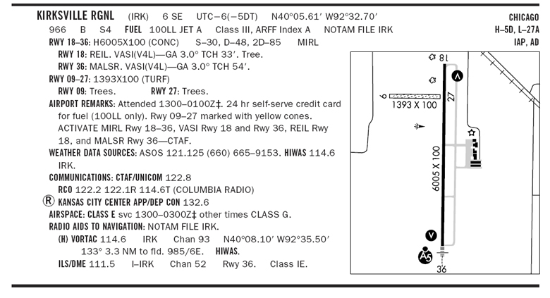
Frequency 122.8 MHz acts as both the CTAF and Unicom frequencies. There is a remote communications outlet available for use at the airport, which permits communications with the Columbia FSS. Frequency 122.2 may be used. Alternatively, communications using the voice feature of the IRK vortac is also possible. To use this method, the pilot would transmit on 122.1, which is a receive only frequency for the FSS. The FSS specialist will respond to the pilot over their transmit only frequency of 114.6. The pilot receives their transmissions by activating the vortac's voice feature.
Radar services to and from the airport are provided by Kansas City Center on frequency 132.6 MHz. This is the frequency you would use to obtain VFR flight following to or from Kirksville, and could also be used if emergency assistance were required. In the event emergency assistance is required, squawking "7700" provides the radar controller rapid identification of your location, provided you are at an altitude sufficient to provide radar coverage.
The airport is in a part time Class E airspace area, between 1300 and 0300 Zulu time. Again, the ++ symbol means these times will be one hour earlier during daylight savings. At other times, the airport is uncontrolled.
The IRK vortac serves the KIRK airport. Kirksville vortac is a high class vortac (can be received up to at least 40 NM, unless very near the ground), and operates on frequency 114.6 MHz (or military channel 93). The Kirksville airport is on the 133 degree radial and 3.3 NM from the vortac. The vortac's elevation is 985 feet MSL and magnetic variation at the vortac is 6 degrees east. The vortac is a HIWAS outlet located at the stated latitude and longitude coordinates.
An instrument landing system approach with distance measuring equipment is provided for instrument guidance to runway 36. The ILS's identifier is I-IRK and it operates on 111.5 MHz or military channel 52. "Class IE" refers to the system's ability to support autoland operations.
On the upper right side of the entry, we are told of the charts available for Kirksville. The airport is charted on the Chicago sectional chart, the high and low enroute charts on chart panels 5D and 27A, and has published instrument approach procedure charts available. "AD" means an airport diagram has been published for this airport. Airport diagrams are located in the back of each A/FD volume alphabetically by associated city and airport name.
The airport sketch shows us the layout of the runways, taxiways, buildings, power lings, fences, towers, obstructions, etc. The VASI locations are shown by the "V" symbols. The "A5" symbol and small representation of the approach lights identifies their type and location. A wind cone is depicted just south of runway 9-27. The airport beacon is just to the north of the airport's buildings.