Navaids
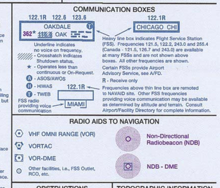
The different navigational aids are depicted on charts as shown in the map legend. A communications box is located near the navaid, which details information about the navaid. The communications box indicates the name, frequency, three letter identifier, and Morse code identifier for the navaid.
Navaid Voice Feature
Some navaids use a voice feature to transmit automated weather, hazardous weather information, or transcribed weather. The transmission of these services is indicated by an "A", "H", or "T" in the communications box, as shown in the legend.
Many navaids use the voice feature to allow pilot communication with the flight service station. Frequencies for the flight service station are shown above the communication box. The name of the associated flight service station is shown below the box.
The letter "R" at the end of a frequency means it is a receive only frequency. To use a receive only frequency, the pilot would transmit to the flight service station with the communications radio over the frequency shown above the communications box. The flight service station responds on the navaid frequency, however. In order to hear the flight service specialist's response, the pilot activates the voice feature of the navaid.
If "R" is not present at the end of the frequency, then the pilot may transmit and receive using the indicated frequency. This is accomplished through the use of a remote communications outlet, or RCO, collocated with the navaid and operating on the indicated frequency.
RCO's are sometimes placed independent of a navaid. When this is the case, the frequency and name of the air traffic control facility in charge of the RCO is shown, according to the map legend.
If the navaid frequency is underlined, it indicates there is no voice available on the navaid frequency.
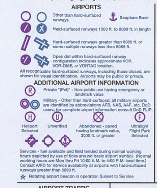
Airport Symbols
Runway lengths on navigation charts are shown to the nearest hundred feet. When rounding, the diversion point is set at 70 feet, however. This means that a runway that is 3,669 feet in length is considered to be 3600' long, whereas a 3,770 foot long runway is shown as being 3800 feet in length.
Hard surface runways charted as having 8,100 or more of runway length are shown with a different symbol than those having hard surface runways 8,000 feet or less in length. However, because of the method of rounding used in determining the charted runway length, the actual distance breakdown between the symbols occurs at 8,070 feet.
Other than hard surface runways are shown with a different airport symbol.
A dot on the airport symbol indicates the location of a navaid on an airport.
Other than hard surfaced military airports have their own symbol. Otherwise, military airport symbols are the same as civilian airports. Seaports are shown with the anchor symbol.
Color of the airport symbol is very important. A blue airport symbol means the airport is towered, while airports with a magenta symbol have no control tower.
Additional Airport Information
Closed and private airports are shown on charts for their landmark or emergency use.
A star at the airport indicates that a rotating beacon is in operation during periods of darkness and poor weather conditions.
Tick marks around the airport symbol indicate fuel is available at the field during normal business hours, which are Monday through Friday from 10 am to 4 pm local time.
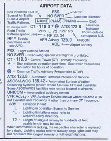
Airport Data
Airport data is shown on the charts, as well. Control tower, CTAF, and ATIS frequencies are listed underneath the airport name and ICAO identifier.
A star next to the control tower frequency indicates the tower operates part time. The "C" symbol indicates the frequency is the CTAF frequency when the tower is closed.
Below the frequencies are listed the airport elevation in feet, followed by the runway length in hundreds of feet (of the longest runway, including unusable portions), and then the unicom frequency. If the runway is lit during hours of darkness, the letter "L" will be shown between the airport elevation and the runway length. A star to the left of the "L" indicates limitations exist on the airport lighting system. The lighting may be available upon request only or be part time. usually, the limitation indicated is pilot controlled lighting. The pilot must consult the airport/facilities directory for more information.
If the airport contains any non-standard, or right hand traffic patterns, the letters "RP" and the runways having right patterns are listed at the bottom of the airport data tag.
If no special VFR operations are permitted at the airport, or if special flight rules apply, the airport data tag will so indicate.