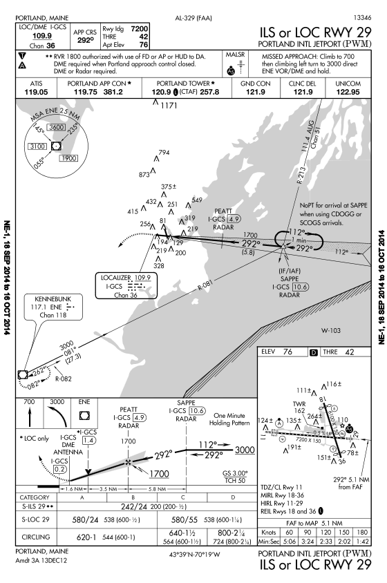
The airport diagram reiterates that runway 29 is MALSR equipped and adds that there is also a PAPI on the right side. The symbol used to depict the runway means it is hard surface runway with centerline lights. Runway 18/36 has no centerline lights. On runway 29 we will have a 0.5% upward gradient. The L symbol next to the statement that runways 18 and 36 are equipped with REIL indicates those REILs are pilot controlled. The D symbol at the top of the airport diagram informs us that declared distance information is available for this airport. Cross checking the A/FD reveals runway 29 has an available landing distance of 7,200 feet.
A time and distance table is given. For this approach, the timing is used for situational awareness. If we flew the approach at 90 knots, it should take us 3 minutes, 24 seconds to travel from PEATT to the decision altitude. Remember, this is ground speed.
A briefing of this approach might sound like this: "This will be the ILS to runway 29 at Portland International Jetport, KPWM, Portland, Maine. The identifier is I-GCS on frequency 109.9. The final approach course is 292 degrees. Runway 29 is 7,200 feet in length and our threshold elevation is 42 feet. The airport elevation is 76 feet. DME or Radar is required, we have both. We will be looking for a MALSR. If we have to go missed, it will be a climb to 700 feet, then a climbing left turn to 3,000 feet, direct to Kennebunk VOR/DME and hold. We will use a direct entry. Our DA is 242 feet, and we need 2400 RVR. Runway 29 has a PAPI and centerline lights, and time on final approach should be 3 minutes, 24 seconds."
If you are flying as part of a crew, you should brief your crew. If you are flying alone, you should brief yourself.
Now it's time to fly the approach. From the enroute phase of flight, air traffic control will likely provide radar vectors to SAPPE and give you descents to a lower altitude. You will then get an approach clearance, which will contain your distance from SAPPE and a turn to intercept the final approach course. If you were coming in from the south and flying on a north vector, your approach clearance might sound like this: "Cessna seven zero eight lima golf, five miles southeast of SAPPE, turn left heading 320, maintain 1700 until established on the localizer, cleared ILS runway 29 approach, contact tower at PEATT."
From here you would join the localizer and glide slope and track the ILS inbound. You still need a clearance to land when tower is open, so don't forget to call them at PEATT, as instructed. The ILS is flown down to the DA. Along the way, we are looking for what we need to see to continue the approach below DA and land. FAR 91.175 specifies what is required to continue the approach below minimums.