Non-Precision Approaches
Since no vertical guidance is provided, non-precision approach procedures involve stepping down to a safe altitude, which is the minimum descent altitude, or MDA. At the MDA, you follow the lateral guidance given for the procedure to the missed approach point, looking for the airport.
There are several types of non-precision approaches. A localizer course is flown similar to an ILS without a glide slope. In fact, should the glide slope portion of an ILS fail, you can still fly the approach as a non-precision, localizer only approach. The back course from an ILS or localizer might be used for a localizer back course approach.
A localizer back course approach is flown similar to a localizer approach, with the exception of reverse sensing. When on a back course approach, you must fly away from the needle, not towards it, to keep it centered. Many aircraft avionics systems will automatically detect and correct for this reverse sensing.
Another approach similar to a localizer approach is the localizer type directional aid, or LDA approach. An LDA is flown with the same technique as a localizer approach. LDA approaches are not aligned with the runway, but straight in minimums will still be published when the final approach course aligns with the runway centerline within 30 degrees. Some LDA approaches also incorporate a glide slope, making them more similar to an ILS. And LDA/GS approach is considered to be an approach with vertical guidance, or APV. LDA course width is approximately 5 degrees.
A simplified directional facility, or SDF approach, is also similar to a localizer. It is just less precise than a localizer, being either 6 or 12 degrees wide. By contrast, localizer course width will be somewhere between 3 and 6 degrees wide.
A VOR or NDB can also be used as the basis for an instrument approach.
Conducting Instrument Approaches
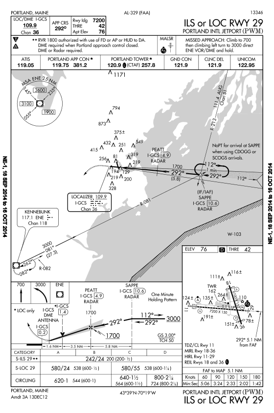
Now that we're familiar with the types of approaches available and their approach charts, let's take a look the procedure for conducting an approach. We'll start off with an example of an ILS, the ILS to runway 29 at Portland, Maine.
First, take a look at the chart and brief yourself or other crewmember. To do this, we will just start at the top and work our way down the chart, making sure we pay close attention to detail. We see this is indeed the chart for the ILS for runway 20 at KPWM, Portland International Jetport, located in Portland, Maine.
Moving on to the briefing section of the chart, we first see the DME equipped ILS frequency is 109.9 MHz. The frequency being underline indicates no voice communications are transmitted on this frequency. The final approach course will be 292 degrees. Runway 29 is 7,200 feet long, its threshold elevation is 42 feet, and the airport elevation is 76 feet.
The symbols in the notes tell us this airport has nonstandard takeoff and alternate minimums. Three notes are then given for this approach. We are first told that visibility minimums of 1800 RVR are authorized with the use of a flight director, autopilot, or heads up display down to decision altitude. The double asterisk at the left connects this note to its partner down in the minimums section. Down there we see that the visibility minimums for this approach are 2,400 RVR otherwise. The next note tells us DME is required with Portland approach is closed. This is because SAPPE and PEATT are both radar fixes, but DME may be substituted. The final note clarifies that DME or radar is required to conduct this approach.
The final approach fix for a nonprecision approach is indicated by the maltese cross symbol in the profile view.